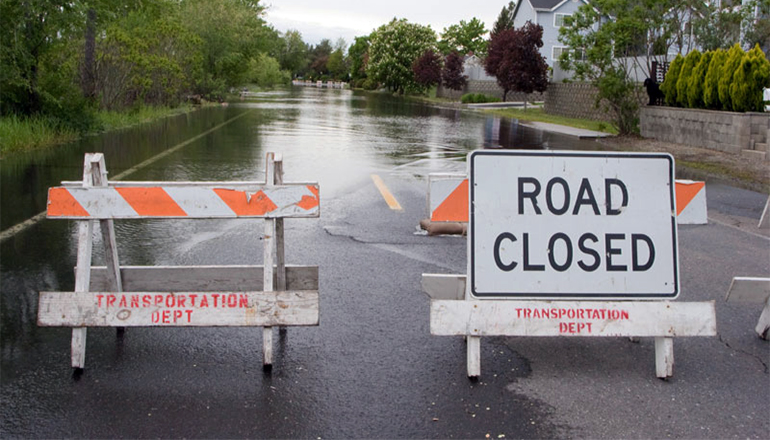
Many areas of northern Missouri received as much a 4-inches or more of rain on Saturday, and along with high winds, damage was extensive. With the rains on Saturday came reports of many road closures due to the flash flooding. Here is a complete list of roads closed due to flooding as reported by MoDOT. You can check on further road closures as well as roads closed due to work and more by clicking THIS LINK.
 State Route 111 – ATCHISON COUNTY – CLOSED
 Flooding reported
Road closed since 03/15/2019.NOTES: Route 111 is closed from Hwy 159 to I-29 due to flooding.
Road closed since 03/15/2019.NOTES: Route 111 is closed from Hwy 159 to I-29 due to flooding.
State Route A – ATCHISON COUNTY – CLOSED Flooding reported beginning CRD 175 ST S, ending RT BB E.
Road closed since 03/13/2019.
Road closed since 03/13/2019.
State Route A – ATCHISON COUNTY – CLOSED Flooding reported beginning .001 mile(s) before RT B E, ending CRD B AVE S.
Road closed since 03/13/2019.
Road closed since 03/13/2019.
State Route BB – ATCHISON COUNTY – CLOSED Missouri
Flooding reported beginning CRD 17 E, ending RT A E.
Road closed since 05/28/2019.NOTES: Please use alternate route
Flooding reported beginning CRD 17 E, ending RT A E.
Road closed since 05/28/2019.NOTES: Please use alternate route
State Route BB – ATCHISON COUNTY – CLOSED Missouri
Flooding reported beginning RT A E, ending CRD 17 E.
Road closed since 05/28/2019.NOTES: Please use alternate route
Flooding reported beginning RT A E, ending CRD 17 E.
Road closed since 05/28/2019.NOTES: Please use alternate route
State Route D – ATCHISON COUNTY – CLOSED Flooding reported beginning RT A E, ending US 136 E.
Road closed since 03/15/2019.NOTES: Route D is closed due to flooding.
Road closed since 03/15/2019.NOTES: Route D is closed due to flooding.
State Route D – ATCHISON COUNTY – CLOSED Flooding reported beginning US 136 E, ending RT A E.
Road closed since 03/15/2019.NOTES: Route D is closed due to flooding.
Road closed since 03/15/2019.NOTES: Route D is closed due to flooding.
State Route E – ATCHISON COUNTY – CLOSED Flooding reported beginning MO 111 S, ending RT U S.
Road closed since 03/15/2019.NOTES: Route E is closed due to flooding.
Road closed since 03/15/2019.NOTES: Route E is closed due to flooding.
State Route E – ATCHISON COUNTY – CLOSED Flooding reported beginning RT U S, ending MO 111 S.
Road closed since 03/15/2019.NOTES: Route E is closed due to flooding.
Road closed since 03/15/2019.NOTES: Route E is closed due to flooding.
State Route U – ATCHISON COUNTY – CLOSED Flooding reported beginning US 136 E, ending CRD 280 ST E.
Road closed since 03/15/2019.NOTES: Route U is closed due to flooding.
Road closed since 03/15/2019.NOTES: Route U is closed due to flooding.
State Route U – ATCHISON COUNTY – CLOSED Flooding reported beginning CRD 280 ST E, ending US 136 E.
Road closed since 03/15/2019.NOTES: Route U is closed due to flooding.
Road closed since 03/15/2019.NOTES: Route U is closed due to flooding.
State Route V – ATCHISON COUNTY – CLOSED Flooding reported beginning .173 mile(s) before PVT FARM RD E, ending CRD 100 ST E.
Road closed since 03/15/2019.NOTES: Route V closed due to flooding.
Road closed since 03/15/2019.NOTES: Route V closed due to flooding.
State Route V – ATCHISON COUNTY – CLOSED Flooding reported beginning CRD 100 ST E, ending .173 mile(s) after PVT FARM RD E.
Road closed since 03/15/2019.NOTES: Route V closed due to flooding.
Road closed since 03/15/2019.NOTES: Route V closed due to flooding.
State Route Z – ATCHISON COUNTY – CLOSED Flooding reported beginning .007 mile(s) after IS 29 S, ending CRD GOLDEN AVE S.
Road closed since 03/15/2019.NOTES: Route Z is closed west of I-29 due to flooding.
Road closed since 03/15/2019.NOTES: Route Z is closed west of I-29 due to flooding.
State Route Z – ATCHISON COUNTY – CLOSED Flooding reported beginning CRD GOLDEN AVE S, ending .007 mile(s) before IS 29 S.
Road closed since 03/15/2019.NOTES: Route Z is closed west of I-29 due to flooding.
Road closed since 03/15/2019.NOTES: Route Z is closed west of I-29 due to flooding.
US 136 – ATCHISON COUNTY – CLOSED Flooding reported
Road closed since 03/15/2019.NOTES: Highway closed from I-29 to the Nebraska state line due to flooding.
Road closed since 03/15/2019.NOTES: Highway closed from I-29 to the Nebraska state line due to flooding.
US 136 – ATCHISON COUNTY – CLOSED Flooding reported
Road closed since 03/15/2019.NOTES: Highway closed from I-29 to the Nebraska state line due to flooding.
Road closed since 03/15/2019.NOTES: Highway closed from I-29 to the Nebraska state line due to flooding.
State Route DD – BUCHANAN COUNTY – CLOSED Malden Creek
Flooding reported beginning .003 mile(s) after CRD HORN S, ending .001 mile(s) before CRD SE 115 S.
Road closed since 06/23/2019.NOTES: Road closed due to flooding. Use alternate route.
Flooding reported beginning .003 mile(s) after CRD HORN S, ending .001 mile(s) before CRD SE 115 S.
Road closed since 06/23/2019.NOTES: Road closed due to flooding. Use alternate route.
State Route DD – BUCHANAN COUNTY – CLOSED Malden Creek
Flooding reported beginning .001 mile(s) after CRD SE 115 S, ending .003 mile(s) before CRD HORN S.
Road closed since 06/23/2019.NOTES: Road closed due to flooding. Use alternate route.
Flooding reported beginning .001 mile(s) after CRD SE 115 S, ending .003 mile(s) before CRD HORN S.
Road closed since 06/23/2019.NOTES: Road closed due to flooding. Use alternate route.
State Route P – BUCHANAN COUNTY – CLOSED Flooding reported beginning .004 mile(s) before CRD MUDDY CREEK NE E, ending MO 6 E.
Road closed since 06/23/2019.NOTES: Road Closed Use Alt RTE
Road closed since 06/23/2019.NOTES: Road Closed Use Alt RTE
State Route P – BUCHANAN COUNTY – CLOSED Third Fork
Flooding reported beginning .532 mile(s) after CRD THORNTON RD S, ending .008 mile(s) before CRD NE 135 S.
Road closed since 06/23/2019.NOTES: Road closed due to flooding. Use alternate route.
Flooding reported beginning .532 mile(s) after CRD THORNTON RD S, ending .008 mile(s) before CRD NE 135 S.
Road closed since 06/23/2019.NOTES: Road closed due to flooding. Use alternate route.
State Route P – BUCHANAN COUNTY – CLOSED Third Fork
Flooding reported beginning .008 mile(s) after CRD NE 135 S, ending .532 mile(s) before CRD THORNTON RD S.
Road closed since 06/23/2019.NOTES: Road closed due to flooding. Use alternate route.
Flooding reported beginning .008 mile(s) after CRD NE 135 S, ending .532 mile(s) before CRD THORNTON RD S.
Road closed since 06/23/2019.NOTES: Road closed due to flooding. Use alternate route.
State Route P – BUCHANAN COUNTY – CLOSED Flooding reported beginning MO 6 E, ending .004 mile(s) after CRD MUDDY CREEK NE E.
Road closed since 06/23/2019.NOTES: Road Closed Use Alt RTE
Road closed since 06/23/2019.NOTES: Road Closed Use Alt RTE
US 59 – BUCHANAN COUNTY – CLOSED Flooding reported beginning .041 mile(s) after MO 273 S, ending .165 mile(s) before MO 45 S.
Road closed since 05/08/2019.
Road closed since 05/08/2019.
US 59 – BUCHANAN COUNTY – CLOSED Flooding reported beginning .165 mile(s) after MO 45 S, ending .041 mile(s) before MO 273 S.
Road closed since 05/08/2019.
Road closed since 05/08/2019.
State Route A – CALDWELL COUNTY – CLOSED Shoal Creek
Flooding reported beginning .018 mile(s) before CRD WISHBONE DR E, ending .016 mile(s) before CRD APPLEWOOD DR E.
Road closed since 06/22/2019.
Flooding reported beginning .018 mile(s) before CRD WISHBONE DR E, ending .016 mile(s) before CRD APPLEWOOD DR E.
Road closed since 06/22/2019.
State Route A – CALDWELL COUNTY – CLOSED Shoal Creek
Flooding reported beginning .016 mile(s) after CRD APPLEWOOD DR E, ending .018 mile(s) after CRD WISHBONE DR E.
Road closed since 06/22/2019.
Flooding reported beginning .016 mile(s) after CRD APPLEWOOD DR E, ending .018 mile(s) after CRD WISHBONE DR E.
Road closed since 06/22/2019.
State Route E – CALDWELL COUNTY – CLOSED Mud Creek
Flooding reported beginning .003 mile(s) before CRD KIRKPATRICK RD S, ending RT A S.
Road closed since 06/23/2019.NOTES: Road closed due to flooding. Use alternate route.
Flooding reported beginning .003 mile(s) before CRD KIRKPATRICK RD S, ending RT A S.
Road closed since 06/23/2019.NOTES: Road closed due to flooding. Use alternate route.
State Route E – CALDWELL COUNTY – CLOSED Mud Creek
Flooding reported beginning RT A S, ending .003 mile(s) after CRD KIRKPATRICK RD S.
Road closed since 06/23/2019.NOTES: Road closed due to flooding. Use alternate route.
Flooding reported beginning RT A S, ending .003 mile(s) after CRD KIRKPATRICK RD S.
Road closed since 06/23/2019.NOTES: Road closed due to flooding. Use alternate route.
State Route F – CALDWELL COUNTY – CLOSED Flooding reported beginning .015 mile(s) before CRD SHOAL STATION DR E, ending .009 mile(s) before RT B S.
Road closed since 06/23/2019.NOTES: Please use an alternate route.
Road closed since 06/23/2019.NOTES: Please use an alternate route.
State Route F – CALDWELL COUNTY – CLOSED Flooding reported beginning .009 mile(s) after RT B S, ending .015 mile(s) after CRD SHOAL STATION DR E.
Road closed since 06/23/2019.NOTES: Please use an alternate route.
Road closed since 06/23/2019.NOTES: Please use an alternate route.
State Route N – CALDWELL COUNTY – CLOSED Mud Creek
Flooding reported beginning RT A S, ending .003 mile(s) after CRD 101 S.
Road closed since 06/23/2019.NOTES: Road closed due to flooding. Use alternate route.
Flooding reported beginning RT A S, ending .003 mile(s) after CRD 101 S.
Road closed since 06/23/2019.NOTES: Road closed due to flooding. Use alternate route.
State Route N – CALDWELL COUNTY – CLOSED Mud Creek
Flooding reported beginning .003 mile(s) before CRD 101 S, ending RT A S.
Road closed since 06/23/2019.NOTES: Road closed due to flooding. Use alternate route.
Flooding reported beginning .003 mile(s) before CRD 101 S, ending RT A S.
Road closed since 06/23/2019.NOTES: Road closed due to flooding. Use alternate route.
State Route 10 – CARROLL COUNTY – CLOSED Walking Dog Creek
Flooding reported beginning .085 mile(s) before PVT FARM RD S, ending .117 mile(s) after CRD 308 E.
Road closed since 05/21/2019.
Flooding reported beginning .085 mile(s) before PVT FARM RD S, ending .117 mile(s) after CRD 308 E.
Road closed since 05/21/2019.
State Route 10 – CARROLL COUNTY – CLOSED Walking Dog Creek
Flooding reported beginning .117 mile(s) before CRD 308 E, ending .085 mile(s) after PVT FARM RD S.
Road closed since 05/21/2019.
Flooding reported beginning .117 mile(s) before CRD 308 E, ending .085 mile(s) after PVT FARM RD S.
Road closed since 05/21/2019.
State Route 10 – CARROLL COUNTY – CLOSED Flooding reported beginning .186 mile(s) after CRD 161 S, ending .046 mile(s) before RT FF S.
Road closed since 06/03/2019.
Road closed since 06/03/2019.
State Route 10 – CARROLL COUNTY – CLOSED Flooding reported beginning .046 mile(s) after RT FF S, ending .186 mile(s) before CRD 161 S.
Road closed since 06/03/2019.
Road closed since 06/03/2019.
State Route 10 – CARROLL COUNTY – CLOSED Flooding reported beginning .023 mile(s) before RT FF S, ending .008 mile(s) after CRD 101 S.
Road closed since 06/03/2019.
Road closed since 06/03/2019.
State Route 41 – CARROLL COUNTY – CLOSED Missouri River
Flooding reported beginning US 24 E, ending .18 mile(s) before RT F E.
Road closed since 05/31/2019.NOTES: MO 41 closed due to flooding. Use Alt Route.
Flooding reported beginning US 24 E, ending .18 mile(s) before RT F E.
Road closed since 05/31/2019.NOTES: MO 41 closed due to flooding. Use Alt Route.
State Route DD – CARROLL COUNTY – CLOSED Flooding reported beginning .009 mile(s) before CRD 131 S, ending .019 mile(s) before CRD 111 S.
Road closed since 06/11/2019.
Road closed since 06/11/2019.
State Route DD – CARROLL COUNTY – CLOSED Flooding reported beginning .019 mile(s) after CRD 111 S, ending .009 mile(s) after CRD 131 S.
Road closed since 06/11/2019.
Road closed since 06/11/2019.
State Route E – CARROLL COUNTY – CLOSED Turkey Creek
Flooding reported beginning .062 mile(s) before RT PP S, ending RT D S.
Road closed since 06/23/2019.
Flooding reported beginning .062 mile(s) before RT PP S, ending RT D S.
Road closed since 06/23/2019.
State Route E – CARROLL COUNTY – CLOSED Turkey Creek
Flooding reported beginning RT D S, ending .062 mile(s) after RT PP S.
Road closed since 06/23/2019.
Flooding reported beginning RT D S, ending .062 mile(s) after RT PP S.
Road closed since 06/23/2019.
State Route FF – CARROLL COUNTY – CLOSED Flooding reported beginning CRD 368 E, ending MO 10 E.
Road closed since 06/02/2019.
Road closed since 06/02/2019.
State Route FF – CARROLL COUNTY – CLOSED Flooding reported beginning MO 10 E, ending CRD 368 E.
Road closed since 06/02/2019.
Road closed since 06/02/2019.
State Route M – CARROLL COUNTY – CLOSED Grand River
Flooding reported beginning .351 mile(s) after CRD 363 S, ending .017 mile(s) before RT Z E.
Road closed since 06/23/2019.
Flooding reported beginning .351 mile(s) after CRD 363 S, ending .017 mile(s) before RT Z E.
Road closed since 06/23/2019.
State Route UU – CARROLL COUNTY – CLOSED Big Creek
Flooding reported beginning .01 mile(s) after CRD 220 E, ending .025 mile(s) before CRD 291 S.
Road closed since 06/23/2019.NOTES: Road closed due to flooding. Use alternate route.
Flooding reported beginning .01 mile(s) after CRD 220 E, ending .025 mile(s) before CRD 291 S.
Road closed since 06/23/2019.NOTES: Road closed due to flooding. Use alternate route.
State Route UU – CARROLL COUNTY – CLOSED Big Creek
Flooding reported beginning .025 mile(s) after CRD 291 S, ending .01 mile(s) before CRD 220 E.
Road closed since 06/23/2019.NOTES: Road closed due to flooding. Use alternate route.
Flooding reported beginning .025 mile(s) after CRD 291 S, ending .01 mile(s) before CRD 220 E.
Road closed since 06/23/2019.NOTES: Road closed due to flooding. Use alternate route.
US 65 – CARROLL COUNTY – CLOSED Missouri River
Flooding reported beginning .01 mile(s) before US 24 W, ending .013 mile(s) after US 24 E.
Road closed since 05/25/2019.
Flooding reported beginning .01 mile(s) before US 24 W, ending .013 mile(s) after US 24 E.
Road closed since 05/25/2019.
State Route 129 – CHARITON COUNTY – CLOSED Chariton River
Flooding reported beginning .028 mile(s) after RT W E, ending .009 mile(s) before RT O E.
Road closed since 06/23/2019.
Flooding reported beginning .028 mile(s) after RT W E, ending .009 mile(s) before RT O E.
Road closed since 06/23/2019.
State Route 129 – CHARITON COUNTY – CLOSED Chariton River
Flooding reported beginning .009 mile(s) after RT O E, ending .028 mile(s) before RT W E.
Road closed since 06/23/2019.
Flooding reported beginning .009 mile(s) after RT O E, ending .028 mile(s) before RT W E.
Road closed since 06/23/2019.
State Route D – CHARITON COUNTY – CLOSED Flooding reported beginning .033 mile(s) after CRD TONKA LN S, ending .477 mile(s) before CRD MUSSEL FORK AVE S.
Road closed since 06/23/2019.NOTES: RTE D Closed Tonka Lane to West of Mussel Fork Creek
Road closed since 06/23/2019.NOTES: RTE D Closed Tonka Lane to West of Mussel Fork Creek
State Route E – CHARITON COUNTY – CLOSED Flooding reported beginning MO 5 S, ending .131 mile(s) after RR MARCELINE SUB E (005271X).
Road closed since 06/21/2019.NOTES: Route E closed for flooding east of Rothville.
Road closed since 06/21/2019.NOTES: Route E closed for flooding east of Rothville.
State Route E – CHARITON COUNTY – CLOSED Flooding reported beginning .131 mile(s) before RR MARCELINE SUB E (005271X), ending MO 5 S.
Road closed since 06/21/2019.NOTES: Route E closed for flooding east of Rothville.
Road closed since 06/21/2019.NOTES: Route E closed for flooding east of Rothville.
State Route J – CHARITON COUNTY – CLOSED Flooding reported beginning .011 mile(s) before CST RAILROAD ST E, ending .008 mile(s) before CRD NAMRASH RD E.
Road closed since 06/23/2019.
Road closed since 06/23/2019.
State Route J – CHARITON COUNTY – CLOSED Flooding reported beginning .008 mile(s) after CRD NAMRASH RD E, ending .011 mile(s) after CST RAILROAD ST E.
Road closed since 06/23/2019.
Road closed since 06/23/2019.
State Route J – CHARITON COUNTY – CLOSED Flooding reported beginning CRD BOWLING GREEN RD E, ending .001 mile(s) before CRD NAMRASH RD E.
Road closed since 05/24/2019.NOTES: Please use alternate route
Road closed since 05/24/2019.NOTES: Please use alternate route
State Route J – CHARITON COUNTY – CLOSED Flooding reported beginning .001 mile(s) after CRD NAMRASH RD E, ending CRD BOWLING GREEN RD E.
Road closed since 05/24/2019.NOTES: Please use alternate route
Road closed since 05/24/2019.NOTES: Please use alternate route
State Route M – CHARITON COUNTY – CLOSED Grand River
Flooding reported beginning .017 mile(s) after RT Z E, ending .351 mile(s) before CRD 363 S.
Road closed since 06/23/2019.
Flooding reported beginning .017 mile(s) after RT Z E, ending .351 mile(s) before CRD 363 S.
Road closed since 06/23/2019.
State Route MM – CHARITON COUNTY – CLOSED Flooding reported beginning RT J S, ending .045 mile(s) before US 24 E.
Road closed since 06/23/2019.
Road closed since 06/23/2019.
State Route MM – CHARITON COUNTY – CLOSED Flooding reported beginning .045 mile(s) after US 24 E, ending RT J S.
Road closed since 06/23/2019.
Road closed since 06/23/2019.
State Route NN – CHARITON COUNTY – CLOSED Rain/weather
Flooding reported beginning .018 mile(s) before CRD DEER RD E, ending CRD RASCAL FLATS RD E.
Road closed since 06/22/2019.NOTES: Please use alt route
Flooding reported beginning .018 mile(s) before CRD DEER RD E, ending CRD RASCAL FLATS RD E.
Road closed since 06/22/2019.NOTES: Please use alt route
State Route NN – CHARITON COUNTY – CLOSED Rain/weather
Flooding reported beginning CRD RASCAL FLATS RD E, ending .018 mile(s) after CRD DEER RD E.
Road closed since 06/22/2019.NOTES: Please use alt route
Flooding reported beginning CRD RASCAL FLATS RD E, ending .018 mile(s) after CRD DEER RD E.
Road closed since 06/22/2019.NOTES: Please use alt route
State Route O – CHARITON COUNTY – CLOSED Chariton River
Flooding reported beginning .002 mile(s) before CRD BLUE GRASS AVE S, ending .018 mile(s) before MO 129 S.
Road closed since 06/23/2019.
Flooding reported beginning .002 mile(s) before CRD BLUE GRASS AVE S, ending .018 mile(s) before MO 129 S.
Road closed since 06/23/2019.
State Route O – CHARITON COUNTY – CLOSED Chariton River
Flooding reported beginning .018 mile(s) after MO 129 S, ending .002 mile(s) after CRD BLUE GRASS AVE S.
Road closed since 06/23/2019.
Flooding reported beginning .018 mile(s) after MO 129 S, ending .002 mile(s) after CRD BLUE GRASS AVE S.
Road closed since 06/23/2019.
State Route WW – CHARITON COUNTY – CLOSED Missouri River
Flooding reported beginning .048 mile(s) after RT KK S, ending .013 mile(s) before CRD SLOUGH RD E.
Road closed since 05/31/2019.
Flooding reported beginning .048 mile(s) after RT KK S, ending .013 mile(s) before CRD SLOUGH RD E.
Road closed since 05/31/2019.
State Route WW – CHARITON COUNTY – CLOSED Missouri River
Flooding reported beginning .013 mile(s) after CRD SLOUGH RD E, ending .048 mile(s) before RT KK S.
Road closed since 05/31/2019.
Flooding reported beginning .013 mile(s) after CRD SLOUGH RD E, ending .048 mile(s) before RT KK S.
Road closed since 05/31/2019.
State Route B – DAVIESS COUNTY – CLOSED Hickory Creek
Flooding reported beginning .017 mile(s) after RT K S, ending .016 mile(s) after CST MAIN ST E.
Road closed since 06/22/2019.NOTES: MO RTE B closed between MO 13 to MO RTE K
Flooding reported beginning .017 mile(s) after RT K S, ending .016 mile(s) after CST MAIN ST E.
Road closed since 06/22/2019.NOTES: MO RTE B closed between MO 13 to MO RTE K
State Route B – DAVIESS COUNTY – CLOSED Hickory Creek
Flooding reported beginning .016 mile(s) before CST MAIN ST E, ending .017 mile(s) before RT K S.
Road closed since 06/22/2019.NOTES: MO RTE B closed between MO 13 to MO RTE K
Flooding reported beginning .016 mile(s) before CST MAIN ST E, ending .017 mile(s) before RT K S.
Road closed since 06/22/2019.NOTES: MO RTE B closed between MO 13 to MO RTE K
State Route M – DAVIESS COUNTY – CLOSED Flooding reported beginning .006 mile(s) before CRD 302 ST S, ending .017 mile(s) after CRD WALTZ AVE E.
Road closed since 06/23/2019.NOTES: Please use an alternate route.
Road closed since 06/23/2019.NOTES: Please use an alternate route.
State Route M – DAVIESS COUNTY – CLOSED Flooding reported beginning .017 mile(s) before CRD WALTZ AVE E, ending .006 mile(s) after CRD 302 ST S.
Road closed since 06/23/2019.NOTES: Please use an alternate route.
Road closed since 06/23/2019.NOTES: Please use an alternate route.
State Route W – GRUNDY COUNTY – CLOSED Hickory Creek
Flooding reported beginning .007 mile(s) after RT F E, ending .042 mile(s) before RT WW E.
Road closed since 06/23/2019.NOTES: Please use an alternate route.
Flooding reported beginning .007 mile(s) after RT F E, ending .042 mile(s) before RT WW E.
Road closed since 06/23/2019.NOTES: Please use an alternate route.
State Route W – GRUNDY COUNTY – CLOSED Hickory Creek
Flooding reported beginning .042 mile(s) after RT WW E, ending .007 mile(s) before RT F E.
Road closed since 06/23/2019.NOTES: Please use an alternate route.
Flooding reported beginning .042 mile(s) after RT WW E, ending .007 mile(s) before RT F E.
Road closed since 06/23/2019.NOTES: Please use an alternate route.
State Route 111 – HOLT COUNTY – CLOSED Flooding reported
Road closed since 03/15/2019.NOTES: Route 111 is closed from Hwy 159 to I-29 due to flooding.
Road closed since 03/15/2019.NOTES: Route 111 is closed from Hwy 159 to I-29 due to flooding.
State Route 118 – HOLT COUNTY – CLOSED Flooding reported beginning MO 111 S, ending .002 mile(s) before RT P S.
Road closed since 03/20/2019.NOTES: Please use alternate route.
Road closed since 03/20/2019.NOTES: Please use alternate route.
State Route 118 – HOLT COUNTY – CLOSED Flooding reported beginning .002 mile(s) after RT P S, ending MO 111 S.
Road closed since 03/20/2019.NOTES: Please use alternate route.
Road closed since 03/20/2019.NOTES: Please use alternate route.
State Route P – HOLT COUNTY – CLOSED Flooding reported beginning US 159 S, ending MO 118 E.
Road closed since 05/30/2019.
Road closed since 05/30/2019.
State Route P – HOLT COUNTY – CLOSED Flooding reported beginning MO 118 E, ending US 159 S.
Road closed since 05/30/2019.
Road closed since 05/30/2019.
State Route W – HOLT COUNTY – CLOSED Flooding reported beginning MO 111 S, ending .016 mile(s) after IS 29 N.
Road closed since 04/15/2019.NOTES: Closed due to flooding, please use alternate route.
Road closed since 04/15/2019.NOTES: Closed due to flooding, please use alternate route.
State Route W – HOLT COUNTY – CLOSED Flooding reported beginning .016 mile(s) before IS 29 N, ending MO 111 S.
Road closed since 04/15/2019.NOTES: Closed due to flooding, please use alternate route.
Road closed since 04/15/2019.NOTES: Closed due to flooding, please use alternate route.
State Route W – HOLT COUNTY – CLOSED Flooding reported beginning MO 111 S, ending .003 mile(s) before RP RTW TO IS29S S.
Road closed since 03/15/2019.NOTES: Route W is closed from Corning to I-29.
Road closed since 03/15/2019.NOTES: Route W is closed from Corning to I-29.
State Route W – HOLT COUNTY – CLOSED Flooding reported beginning .003 mile(s) after RP IS29S TO RTW S, ending MO 111 S.
Road closed since 03/15/2019.NOTES: Route W is closed from Corning to I-29.
Road closed since 03/15/2019.NOTES: Route W is closed from Corning to I-29.
US 159 – HOLT COUNTY – CLOSED Flooding reported
Road closed since 03/15/2019.NOTES: Road closed from Route P to the Nebraska state line due to flood waters over the roadway.
Road closed since 03/15/2019.NOTES: Road closed from Route P to the Nebraska state line due to flood waters over the roadway.
US 159 – HOLT COUNTY – CLOSED Flooding reported
Road closed since 03/15/2019.NOTES: Road closed from Route P to the Nebraska state line due to flood waters over the roadway.
Road closed since 03/15/2019.NOTES: Road closed from Route P to the Nebraska state line due to flood waters over the roadway.
State Route B – LINN COUNTY – CLOSED Flooding reported beginning .002 mile(s) after RT Y S, ending .017 mile(s) after CST STATE ST E.
Road closed since 06/23/2019.NOTES: Road Closed Use ALT RTE
Road closed since 06/23/2019.NOTES: Road Closed Use ALT RTE
State Route B – LINN COUNTY – CLOSED Flooding reported beginning .017 mile(s) before CST STATE ST E, ending .002 mile(s) before RT Y S.
Road closed since 06/23/2019.NOTES: Road Closed Use ALT RTE
Road closed since 06/23/2019.NOTES: Road Closed Use ALT RTE
State Route C – LINN COUNTY – CLOSED W Yellow Creek
Flooding reported beginning .087 mile(s) after RT V S, ending .04 mile(s) before RT CC S.
Road closed since 06/22/2019.NOTES: Use alt route.
Flooding reported beginning .087 mile(s) after RT V S, ending .04 mile(s) before RT CC S.
Road closed since 06/22/2019.NOTES: Use alt route.
State Route C – LINN COUNTY – CLOSED W Yellow Creek
Flooding reported beginning .04 mile(s) after RT CC S, ending .087 mile(s) before RT V S.
Road closed since 06/22/2019.NOTES: Use alt route.
Flooding reported beginning .04 mile(s) after RT CC S, ending .087 mile(s) before RT V S.
Road closed since 06/22/2019.NOTES: Use alt route.
State Route WW – LINN COUNTY – CLOSED Flooding reported beginning .064 mile(s) after CST HAUSER ST E, ending .541 mile(s) before CRD ALMOND AVE S.
Road closed since 06/23/2019.NOTES: ROAD CLOSED USE ALT ROUTE
Road closed since 06/23/2019.NOTES: ROAD CLOSED USE ALT ROUTE
State Route D – LIVINGSTON COUNTY – CLOSED Shoal Creek
Flooding reported beginning .402 mile(s) after CST MAIN ST S, ending .099 mile(s) before CRD 430 E.
Road closed since 06/23/2019.NOTES: Use Alt Route
Flooding reported beginning .402 mile(s) after CST MAIN ST S, ending .099 mile(s) before CRD 430 E.
Road closed since 06/23/2019.NOTES: Use Alt Route
State Route D – LIVINGSTON COUNTY – CLOSED Shoal Creek
Flooding reported beginning .099 mile(s) after CRD 430 E, ending .402 mile(s) before CST MAIN ST S.
Road closed since 06/23/2019.NOTES: Use Alt Route
Flooding reported beginning .099 mile(s) after CRD 430 E, ending .402 mile(s) before CST MAIN ST S.
Road closed since 06/23/2019.NOTES: Use Alt Route
State Route DD – LIVINGSTON COUNTY – CLOSED Shoal Creek
Flooding reported beginning RT C S, ending .023 mile(s) before RT D S.
Road closed since 06/23/2019.NOTES: Use Alt Route
Flooding reported beginning RT C S, ending .023 mile(s) before RT D S.
Road closed since 06/23/2019.NOTES: Use Alt Route
State Route DD – LIVINGSTON COUNTY – CLOSED Shoal Creek
Flooding reported beginning .023 mile(s) after RT D S, ending RT C S.
Road closed since 06/23/2019.NOTES: Use Alt Route
Flooding reported beginning .023 mile(s) after RT D S, ending RT C S.
Road closed since 06/23/2019.NOTES: Use Alt Route
State Route PP – SULLIVAN COUNTY – CLOSED West Locust Creek
Flooding reported beginning RT E E, ending .016 mile(s) before RT W S.
Road closed since 06/23/2019.
Flooding reported beginning RT E E, ending .016 mile(s) before RT W S.
Road closed since 06/23/2019.
State Route PP – SULLIVAN COUNTY – CLOSED West Locust Creek
Flooding reported beginning .016 mile(s) after RT W S, ending RT E E.
Road closed since 06/23/2019.
Flooding reported beginning .016 mile(s) after RT W S, ending RT E E.
Road closed since 06/23/2019.


