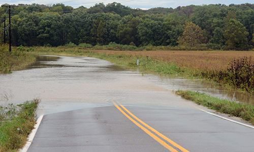
Route 48 and Route C in Rosendale are now open after floodwaters from the One Hundred and Two River receded. Please consult the list below for the roads throughout North Missouri that are currently closed due to flooding.
Remember, situations can change quickly, especially during flooding. Motorists are reminded to stay alert and to not drive through any water over the roadway. It only takes six inches of water (or less!) to lose control of your vehicle and possibly be swept into rising floodwaters. Any time there is water over the roadway, there may be damage to the road surface below. MoDOT encourages all motorists to Turn Around! Don’t Drown!
To keep up with the latest road closures for flooding, incidents and roadwork, the Missouri Department of Transportation provides a Traveler Information Map at www.modot.org/northwest. Motorists are advised to check the map or call 1-888 ASK MODOT (1-888-275-6636) before heading out to plan alternate routes, as needed.
NOW CLOSED:
Buchanan County
- Route C from U.S. Route 36 to Saxton Easton Road SE west of Easton (Third Fork)
- Route H from Route FF to 90th Road SE in Agency (Platte River)
- Route M from Rock Creek to Loutermilch SE south of Agency (Platte River)
- Route FF from Possum Holler to Route H in Agency (Platte River)
Caldwell County
- Route A from Toledo Drive to Wishbone Drive south of U.S. Route 36 (Shoal Creek)
Livingston County
- Route C from U.S. Route 36 to Route DD near Utica (Shoal Creek)
- Route DD from Route D to Route C northeast of Ludlow (Shoal Creek)


