The National Weather Service in Pleasant Hill, in a late afternoon update, has now presented a timeline for the wintry weather that will move into northern Missouri Tuesday. In the same update, they have also expanded the Winter Weather Advisory to include all counties north of Highway 35 with the exception of Lewis, Marion, and Shelby counties in eastern Missouri. The Winter Weather Advisory will extend from Noon on Tuesday, to 6 am on Wednesday, December 30. 2020.
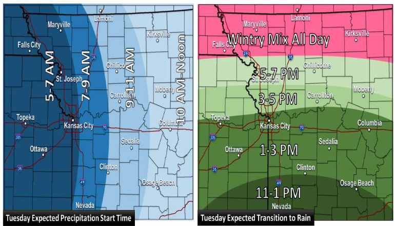
The Weather service now indicates a combination of snow and ice will impact northern Missouri on Tuesday morning affecting commuters. The mix of snow and freezing rain should begin between 7 and 9 am Tuesday morning with accumulations through Tuesday evening. Ice accumulations of up to 1/10 of an inch is expected south of Highway 36 and ice accumulations north of Highway 36 are expected to be as much as 1/4 of an inch. Snow south of the Highway 36 corridor is expected to accumulate to around one inch, while snow north of Highway 36 is expected to be from two to four inches with higher amounts the closer you get to the Iowa/Missouri border. The highest amounts of snow will occur in northwest Missouri.
A transition to rain will occur Tuesday afternoon/evening with a timeline that indicates from 1 to 3 pm for areas south of the Missouri River, from 3 to 5 pm for areas north of the Missouri River, and from 5 to 7 pm for areas extending from St. Joseph to points east.
At this hour (8:00 pm) the National Weather Service is uncertain as to how far north the rain/mix line will extend, however, the wintry mix is expected to continue for far northwest Missouri through early Tuesday evening. There is the potential to briefly transition back to a wintry mix on Wednesday morning and afternoon, however, no additional accumulations are expected on Wednesday.
The forecast for northern Missouri as of 8:00 pm, Monday evening, December 28, 2020, is as follows:
Tonight: A slight chance of snow after 5 am. Increasing clouds, with a low around 25. Light and variable wind becoming east 5 to 8 mph after midnight. Winds could gust as high as 18 mph. Chance of precipitation is 20%.
Tuesday: Snow and sleet, possibly mixed with freezing rain before 3 pm, then freezing rain, possibly mixed with sleet between 3 pm and 4 pm, then freezing rain after 4 pm. High near 33. East southeast wind 9 to 18 mph, with gusts as high as 30 mph. The chance of precipitation is 90%. New ice accumulation of 0.1 to 0.3 of an inch possible. New snow and sleet accumulation of 1 to 2 inches possible.
Tuesday Night: Freezing rain before 8 pm, then rain between 8 pm and 5 am, then rain and snow likely after 5 am. Low around 29. Southeast wind 6 to 15 mph becoming west northwest after midnight. Winds could gust as high as 22 mph. The chance of precipitation is 90%. New ice accumulation of around 0.1 of an inch possible. Little or no snow accumulation expected.


